Several cities in Southern California are expecting heavy bouts of rain Wednesday through Friday, with the flash flood risk increased in burned areas.
Why It Matters
In January, several massive wildfires tore through Southern California. The flames have since been extinguished but have left behind burn scars, which enhances the risk of floods and debris flows.
Incoming rain could help remedy the dry start to the winter that Southern California has seen so far, but it also comes with hazards that National Weather Service (NWS) meteorologists are warning about.
What To Know
On Tuesday, multiple NWS offices in Southern California issued weather alerts related to the incoming rainstorm, including a flash flood watch, a wind advisory and a flood watch.
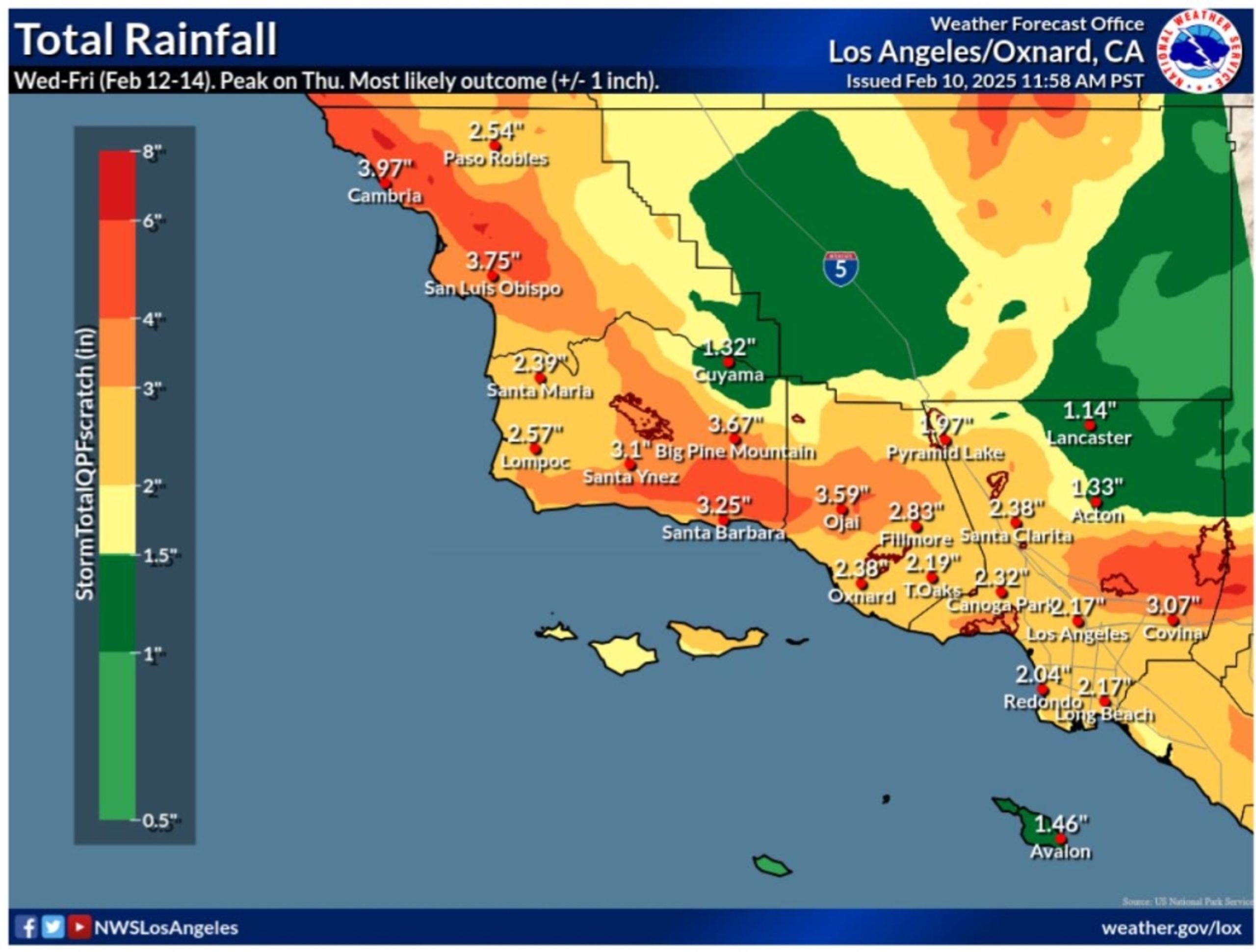
A rainfall map shared by the NWS office in Los Angeles shows widespread amounts of 2 to 3 inches of rain expected from north of Paso Robles to south of Long Beach.

National Weather Service
For lower elevation areas, rainfall is expected to be between 1 and 3 inches on average. However, higher elevations are expecting even more rain, with 6 to 10 inches forecast for the mountains. Some mountainous regions could see rainfall amounts as high as 10 inches.
The NWS Los Angeles office warned of a moderate risk of significant floods and debris flows, as well as a high risk for swift water rescues and urban flooding. The most significant risks will occur on Thursday.
In San Diego, the NWS office warned that there’s a high risk of floods from Thursday at 1 p.m. local time to 4 a.m. on Friday. The highest risks were in place for the San Bernardino Mountains, Inland Empire, the Riverside Mountains, the Santa Ana Mountains, the Orange County coast and inland, San Diego County’s mountains and the San Diego County valleys and coast. The office warned of “life-threatening debris flows” in and around recent burn scars.
Since October 1, the start of the water year, downtown Los Angeles has received only 2.65 inches of rain. The typical amount the city sees from October 1 to February 11 is 8.3 inches.
What People Are Saying
NWS meteorologist Bryan Lewis, who works at the Los Angeles office, told Newsweek: “Thursday to Thursday night is the period we are expecting the most rain. [Debris flows] would be the biggest concern, but even low-lying creeks could flood from this.”
The NWS San Diego office said on X (formerly Twitter): “Have you heard about the rain? We’re going to see a substantial rain event later this week, with everywhere from the coast to the deserts getting in on the action! While some snowfall at the highest elevations expected, snow levels will generally remain high, above 7500 ft.”
What Happens Next
Despite the incoming storm, the NWS Climate Prediction Center anticipates that the next six to 10 days will see above-average temperatures and below-average precipitation for Southern California.