Millions of Americans along the East Coast are expecting heavy rain, strong winds, and cold temperatures through Friday as a rare spring Nor’easter brings severe weather to the region.
Why It Matters
Nor’easters are powerful storms more typical during the winter months, when they bring heavy snowfall that, when coupled with strong winds, can cause blizzards. Because of warmer temperatures, snow isn’t expected with the incoming storm except for high-elevation areas, but heavy rain is likely. AccuWeather meteorologists are predicting several inches of rain to fall through Friday morning.
Coastal flood advisories and gale warnings have already been issued by the National Weather Service (NWS) in Northeastern states, with more weather alerts possible before the storm is over.
What To Know
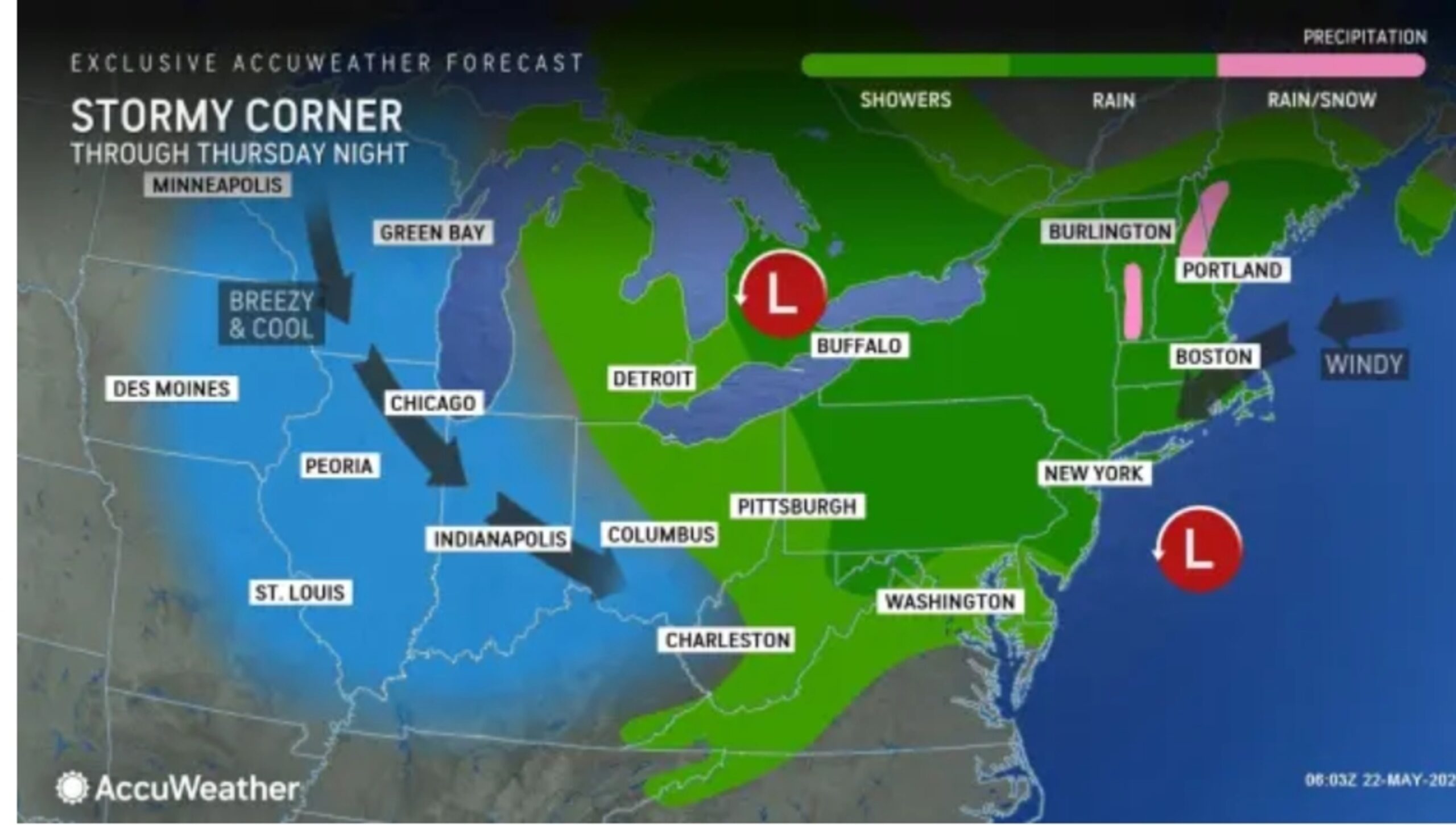
Along with severe weather, temperatures will plunge across the Northeast until the air feels more becoming of March or April, AccuWeather said in a report. The coldest states will be Massachusetts, New Hampshire, and Vermont, where temperatures will feel as low as 30 degrees Fahrenheit. Cool temperatures will stretch into the Midwest.

AccuWeather
Virginia northeast through Maine and northwest through Ohio and Michigan are expecting showers from the storm, with some high-elevation snow possible in Vermont and New Hampshire.
The heaviest rainfall is expected across western Pennsylvania, western Maryland, and northeastern West Virginia, as well as along the coast in Maryland, Connecticut, and Rhode Island, with 2 to 4 inches expected.
Wind will pose the biggest impacts, with some gusts reaching up to 50 mph, AccuWeather senior meteorologist Tom Kines told Newsweek. Some winds could gust even higher in Cape Cod or eastern Long Island.
In addition to creating unsatisfactory weather, NWS meteorologists warned that the winds would cause hazardous seas and urged boaters to take caution.
“Strong winds will cause hazardous seas which could capsize or damage vessels and reduce visibility,” a gale warning issued by the NWS office in New York said. “Mariners should alter plans to avoid these hazardous conditions. Remain in port, seek safe harbor, alter course, and/or secure the vessel for hazardous conditions.”
What People Are Saying
AccuWeather senior meteorologist Tom Kines told Newsweek: “No doubt it’s unusual for this time of year. It happens, but it’s certainly not a common event. It’s something we talk about in the winter with these storms. They usually form along the mid-Atlantic Coast and intensify and move northeastward, and they bring a lot of wind, rain and or snow to parts of the Northeast.”
An NWS forecast issued on Thursday morning: “A relatively stagnant upper pattern with troughing along the coasts and ridging over the Central U.S. will persist through the end of the week. Low pressure in the East will produce cool and rainy weather from the Ohio Valley to the Northeast/Mid-Atlantic. Some isolated thunderstorms could produce excessive rainfall over portions of southern New England today but that threat is marginal.”
What Happens Next
The storm’s impacts are expected to persist through Friday. Temperatures are expected to trend upward for the Northeast later this month, with the NWS Climate Prediction Center’s eight- to 14-day temperature outlook showing above-average temperatures for the region through the end of May.